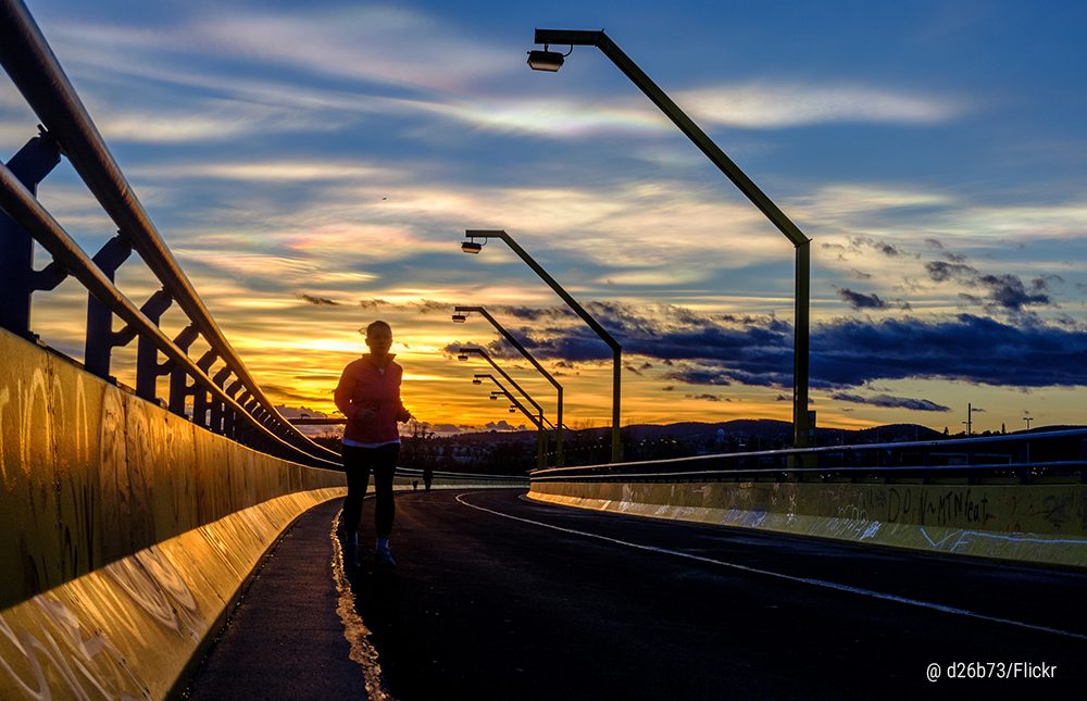
Island running on the Donauinsel

Difficulty level: my granny could run the 10k here while baking a cake. The island is easy to run.
Why it’s fun for a run?
The Donauinsel is one of our favourite places to go running. Did you know it’s over 21km long, and is 120m wide in some places? You can run here every week of the year and take a different route each time. Also, it’s almost impossible to get lost, as you can run from east to west (or vice versa) and you’ll just hit the water of the Danube either side.
The size of the island means you’ll never have to deal with the weekend warrior crowds, making it one of the best places to get some solitary run time. Also, the paths are marked every 100 meters, making it ideal for some serious interval training.
Suggested running routes: It’s hard to suggest one particular route, but if you’re looking to just run around the island, start out at the U-Bahn station Donauinsel and head towards the Praterbrücke. From there, you can either cross the bridge into the Prater (5km):
Run like a royal at Schönbrunn

Difficulty level: A reasonably fit Habsburger with their heavy lip could cover this one, no worries.
Why it’s fun for a run?
This one is for those that get lost easy and like an order to their runs. The neat, straight, layout of the gardens around the Schönbrunn Palace and the nearby zoo, Tiergarten Schönbrunn, are ideal for those that want to get a quick run in at the beginning, or the end of the day. And if you like it so much the first time round and have enough energy leftover, go for a 2nd round of the same track. It’s so peaceful and beautiful here, you won’t even notice you’ve passed that same tree 3 times.
Suggested routes: We’d suggest you make it up as you go along here, but be sure to include a run up the hill leading towards the Gloriette café behind the palace, and do a Rocky Balboa triumphant jump with both hands in the air – the run downhill is well worth it.
Here’s a route suggestion below (approx. 4km) which will take you on a tour through the forest behind the zoo. Be sure to make a few elephant mating calls as you pass by!
The runner’s playground: the mighty Prater

Difficulty level: for adventurous, off-road runners, or for those that need to be chased by a smiling clown with a knife to be inspired to run
Why it’s fun for a run?
Are we going to call it Vienna’s Central Park? No. But we could. But we’re not. It wouldn’t do the place justice. There’s just such a unique vibe to the Prater. And we’ve run through all the little nooks and crannies in this park, therefore we can tell you from experience, it’s a runner’s playground.
There’s something for everyone, whether you prefer to run on a paved surface, head into the woods, or slush it out on the horse trails, you can do it all at the Prater. And there’s few hills here, making it easy on the calves.
There are paths weaving everywhere, and it’s easy to feel lost, but the good thing is that even if you do get lost, you’ll always find your way back to the Hauptallee. Also, you can use landmarks like the Ernst Happel Stadium or the big Riesenrad (the ferris wheel) to help you orientate yourself. This is also the place to go if you’re a social runner. It’s always crowded, especially on the weekends and during the late afternoon and early evening. The Hauptallee is lit, so you’ll feel safe running here after dark.
Suggested running routes: For a simple, straight (literally) forward run, you can run from the Praterstern U-Bahn station to the Lusthaus, taking the entire Hauptallee (4.3km) in your stride. This is especially nice after dark and the other paths are harder (and less safe) to navigate. You can change it up by taking the paved main road, or the dirt horse trails:
If you’re looking to take a paved and off road combination, try this route. It takes you past the Ernst Happel Stadion, along a nice little pond towards the Lusthaus, and back via the Arenawiese. It’s a comfortable 9.1km run and especially nice when the sun’s out!
Or there’s the simple up and down along the nearby harbor promenade, which goes along the Danube river:
Run along the promenade of the Donaukanal

Difficulty level: From beginners (who will stop at the various beach bars along the way for a quick Spritzer) to advanced (those that run such long distances, they pack toilet paper)
Why it’s fun for a run:
The Donaukanal is one of the most accessible and green spaces in Vienna, and is one of the most unique features of the city – a waterway lined with greenery smack bang in the inner city. There’s high foot and bike traffic on the promenade in front of Schwedenplatz, between Salztorbrücke and Aspernbrücke, however either side of this you can run with plenty of space, along with other fitness junkies.
Running along the Donaukanal offers the perfect mix of nature and urbanity, not to mention the street art and graffiti gallery that your eyes will stick to for a lot of the way.
Suggested routes: We’d suggest beginning at Schwedenplatz, and running towards the 3rd district (see Donaukanal route 1 on the map), or starting at the U4 Roßauer Lände station and heading out of the city (see Donaukanal route 2 on the map). Both will have you running approximately 7km.
Run like a Würstel – Here’s a few custom-made routes we’ve made just for you:
Our favourite 18k training run through the park

Distance: 18km
Difficulty level: perfect for those running the Vienna half city marathon
This will take you past the Donaukanal, through a little known forest path in Prater and past the Freudenauhorse racing track. From there, you run towards the hydro-electric dam, go over it and run about 5km on the Donauinsel. Here, you’ll cross back into the Prater using the Praterbrücke. It’s a lovely run with paved and unpaved paths, and you’ll have most parts to yourself.
Run the ring: The Ringstrasse boulevard

Distance: approx. 6.5km
Difficulty level: For those that often confuse the words run and rum when written in their calendar
This one is for those who like the slideshow of the urban setting on their running route. While plenty of foot traffic and bikers use the Ringstrasse boulevard that encircles Vienna’s old city centre, there’s plenty of room for the attentive runner as well. Just imagine you’re in one of those old video games where you have to dodge and weave past all the monsters. Just think, you can do this all while marvelling at Vienna’s old charm with some of the city’s most handsome buildings on the way. Our suggested ring run route also takes you through the beautiful Stadtpark where you can collapse on the grass and take in the smells, sounds and atmosphere that this beloved park possesses. Or you can jump on the playground on the 3rd district side of the Wienfluss(Wien river). Otherwise, you can just keep running and rest later at the finish line on the Donaukanal.
The more hardcore route is in pink (naturally) and extends the running route another 4km, heading along a quiet, leafy green section of the Donaukanal.
Go the Gürtel – Running the belt and onto the Wienfluss

Distance: ‘From the belt to the Wien river route’ = 8km one way, or 16km return & the ‘Extension of the Gürtel’ route = 4.5km. The two routes combined one-way = 12.5km
Difficulty level: For those that run like the law is after them and they have to flee the country.
There’s a paved path following the elevated U6 U-Bahn line tracing the Gürtel. This offers an immersive urban running route. Sandwiched between two highways, this is not the healthiest of routes with the car fumes and all, therefore we wouldn’t recommend making this your regular running trail. However, this is one of our favourite trails to run, even though each time we do it, we’re reminded how the numerous traffic lights can be annoying. There are a couple of options regarding distance, where to begin and where to end, with this route:
1. Begin at Spittelau and combine both routes (see map) by running all the way to Hütteldorf. There is a paved path the entire stretch. If you want to push yourself, we’d recommend running up and down the hundreds of stairs at the Hauptbücherei Wien (Vienna’s main library). When you arrive in Hütteldorf, you can catch the U-Bahn back into town.
2. Begin at the Hauptbücherei Wien (U6 station Burggasse; Urban-Loritz-Platz), and run the ‘from the belt to the Wien river’ route to Hütteldorf and back, or just one way if you’re looking to do an easy run.
Get content that you love in your inbox!